Where Would the First Mars Colony Land? The Shortlist
NASA collected 47 candidate zones; a SpaceX and JPL study narrowed to seven sites near 39°N. Why ice, sunlight and thin air pull a first Mars base three ways.
Nobody has chosen the spot yet. But the search has narrowed a long way: NASA collected 47 candidate zones at a 2015 workshop, and a 2021 study written jointly by SpaceX and JPL researchers carried seven sites forward, five of them in one region of northern plains called Arcadia Planitia, near 39°N.
Every plan for a first Mars colony hits the same wall before it reaches habitats, greenhouses or power budgets. No single place on Mars satisfies all the requirements at once.
Water ice lies toward the poles. Sunlight and survivable temperatures lie toward the equator, and air thick enough to slow a descending spacecraft lies at low elevation. A landing site is what you get after trading those against each other, which is why the same handful of names keeps recurring.
Where does NASA say a first crew should land?
It has not said. What NASA did was ask. From 27 to 30 October 2015 the agency ran its First Landing Site/Exploration Zone Workshop for Human Missions to the Surface of Mars at the Lunar and Planetary Institute in Houston, and 47 proposals for Exploration Zones and Regions of Interest were presented and discussed.
The workshop introduced a unit of planning that still shapes the argument. An Exploration Zone is a collection of Regions of Interest sitting within roughly 100 kilometres of one central landing site. That radius encodes an assumption about how far a crew can practically travel and return. Pick a landing point and you are really picking everything inside a 100 km reach: the science, the ice, the construction material.
No site was selected then, and none has been selected since. Those 47 proposals were a call for ideas rather than a contest with a winner.
Why not just land at the equator?
Because two of the three constraints point that way and the most important one does not.
Start with the descent. Mars has about one percent of Earth's surface air pressure, so every kilometre of elevation you give up buys atmosphere to brake against. The constraint is written into real missions: InSight required a site at or below 2.5 km beneath the reference level, according to the published account of its landing site selection. Mars 2020 could accept ground as high as 0.5 km below the datum because a range trigger and terrain-relative navigation had tightened its accuracy.
Then power and heat. The Mars Exploration Rovers were held to a band between 10°N and 15°S for solar output; InSight was held between 3°N and 5°N. Those are robotic solar constraints rather than crew constraints, but the physics behind them does not change for people. Surface engineering adds its own limits: slopes under 15° at both 2-metre and 84-metre scales, and rock coverage under 10% so a lander does not tip.
One number is worth holding on to. InSight's ballistic entry gave a landing ellipse of 130 by 27 kilometres. You do not choose a point on Mars. You choose an area, and you have to be willing to live anywhere inside it.
So the equator wins on sunlight, warmth and, in the low basins, on air. It loses on the resource that decides whether a base can grow at all: reachable water.
Where is the ice shallow enough to matter?
This is the question the last decade of orbital work has been answering. The Subsurface Water Ice Mapping project (SWIM), run through the Planetary Science Institute for NASA's Mars Exploration Program, combines orbital data into ice consistency maps at about 3 km per pixel across three depth bands: 0 to 1 metre, 1 to 5 metres, and deeper than 5 metres.
Two findings from that work matter for a colony. Human landing site selection is expected to concentrate below 50° latitude, where sunlight is strong enough to support long surface operations and to keep hardware from freezing. And the shallowest ground ice reaches surprisingly far equatorward, with excursions below 30° north and south. The 2020 Nature Astronomy paper on northern mid-latitude ice resources singled out Deuteronilus Mensae and Arcadia Planitia as the promising ground.
Orbital inference is one thing. Direct sampling is another, and Phoenix remains the only mission to have excavated near-surface water ice and confirmed it on the spot. It landed at 68.22°N and confirmed water ice on 31 July 2008, after its arm reached ice roughly 5 centimetres down. In the trench the team nicknamed Dodo-Goldilocks, bright material sublimed away over four days, between sol 20 and sol 24, which is how they knew it was water and not salt.
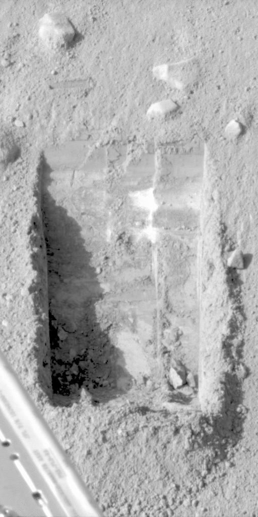
Bright material vanishing from the Dodo-Goldilocks trench over four sols: sublimation, and so water ice rather than salt. Credit: NASA/JPL-Caltech/University of Arizona/Texas A&M University. Source: NASA image PIA10906
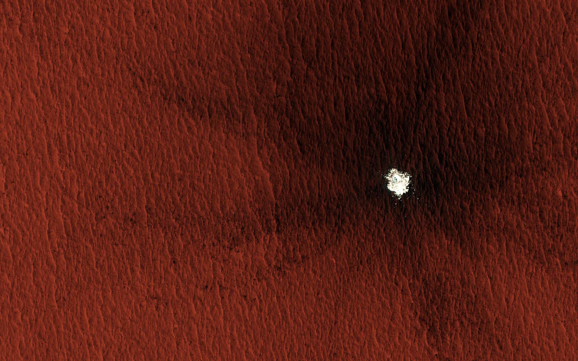
Phoenix proved the ice exists but sat far too near the pole to be a settlement candidate. Its solar power faded with the northern winter and the mission ended. The useful ground is further south, and fresh impacts have been quietly mapping it: over two decades the HiRISE and Context cameras on Mars Reconnaissance Orbiter catalogued hundreds of new craters, and some at mid to high latitudes punched straight into buried ice. One 13-metre crater in Arcadia Planitia exposed ice in both its cavity and its ejecta, with a dark blast zone reaching almost 850 metres from the centre. That crater is the image at the top of this article.
Later orbital work has kept pointing the same way. Successive SWIM mapping rounds have continued to support extensive shallow ground ice across Arcadia rather than walking the interpretation back.
What has SpaceX publicly studied?
A study list, not a destination. At the 2021 Lunar and Planetary Science Conference, a paper titled SpaceX Starship Landing Sites on Mars set out seven sites selected for further study. The affiliations behind it are the interesting part: JPL and SpaceX appear side by side, together with the University of Arizona, the Planetary Science Institute, Purdue, Brown and NASA Ames. A company and a NASA centre were working the siting problem together, in the open literature.
Five of the seven sit in Arcadia Planitia. The others fall in Phlegra Montes and Erebus Montes, hillier ground on the same northern plains. The region ticks the boxes the trade demands at once: low elevation for the descent, smooth and rock-poor ground for touchdown, and evidence of shallow ice for everything after.
The candidates were imaged in detail from orbit. HiRISE frame ESP_060416_2195, one of the candidate site images released by the University of Arizona, is centred at 39.083°N, 189.793°E. That latitude is the whole argument in one number: far enough north to reach ice, far enough south to keep the Sun useful.
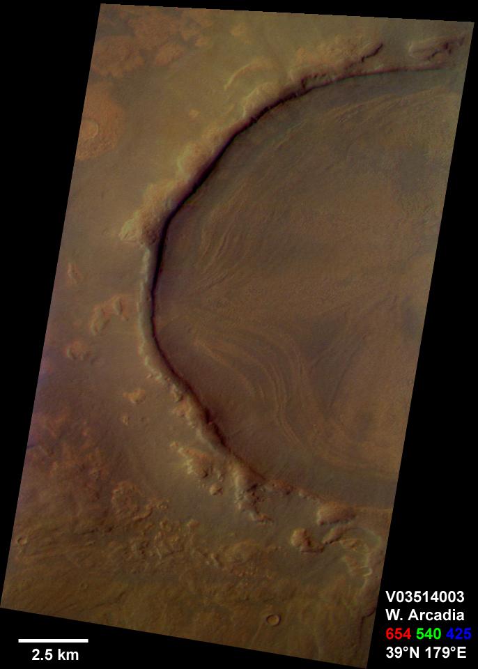
Western Arcadia Planitia near 39°N, 179°E. The concentric layers and slumped material inside this crater are the kind of feature that points to surface or subsurface ice. Credit: NASA/JPL/Arizona State University/Cornell University. Source: NASA image PIA04263
Two cautions. A candidate is not a choice, and the 2021 list came out of a research collaboration rather than a corporate announcement. As of July 2026, neither NASA nor SpaceX has published a revised shortlist replacing those seven candidate sites, so treat any larger number you see quoted as unverified.
How does the shortlist compare?
The names that recur, and what each one is actually offering:
Arcadia Planitia, near 39°N. Five of the seven Starship study sites. Low elevation, smooth terrain, shallow ice inferred from orbit and confirmed in places by fresh craters. The most frequently discussed candidate region in the current landing-site literature, though nothing official ranks it first.
Phlegra Montes and Erebus Montes. The other two study sites. Ice-related terrain with more relief, which buys geological variety and costs landing margin.
Deuteronilus Mensae. SWIM's other northern highlight, with glacier-like fill. Strong on ice, less studied as a landing problem.
Jezero Crater, 18.44°N, 77.45°E, floor around 2,600 metres below the reference level. Where Perseverance works. Superb science, an ancient river delta, and no particular claim to accessible ice.
Oxia Planum, 18.28°N, 335.37°E, its clay unit running from about 2,600 to 3,100 metres below datum. The target for ESA's Rosalind Franklin rover, chosen for ancient clays rather than resources.
Utopia Planitia, 47.97°N. Where Viking 2 landed in 1976, and still the second-highest latitude any spacecraft has reached intact on Mars.
Read down that list and the split is hard to miss: the science targets sit near 18°N while the resource targets sit near 39°N and above. A first colony has to decide which kind of place it wants to be.
What do the robotic landings already tell us?
We keep the coordinates of every located Mars landing site in one dataset behind our interactive Mars map, so the latitude question can be checked rather than argued. Twelve located sites are plotted. Counting them produces a blunt result.
Only two sit above 30°N: Viking 2 at 47.97°N and Phoenix at 68.22°N. Every rover that has ever driven on Mars landed within about 25° of the equator, from Opportunity at 1.95°S to Zhurong at 25.07°N. The one site far south is Mars 3 at 45°S, which fell silent after roughly 20 seconds in 1971.
In other words, the band where the ice is has almost never been visited, and never by anything mobile. Two sites in our dataset are deliberately missing for the same reason we trust the rest of it: Mars 2 and Mars Polar Lander both crashed and their impact points were never located, so plotting them would mean inventing a coordinate. Beagle 2 is on the map because orbital imaging found its wreck in 2015.
The mission record behind those pins is set out in our timeline of Mars missions, and what a base would have to build once it arrives is covered in our guide to colonizing Mars.
What we still do not know
The honest gaps, because they are larger than the settled parts:
No agency or company has selected a landing site for a first crewed mission, let alone a permanent base.
Ice depth and purity at every candidate site are inferred from orbit. The only ground truth on Mars ice came from Phoenix, 29 degrees of latitude north of the Arcadia candidates.
The trade between ice access and solar power has no agreed answer. SWIM frames a sweet spot at the southern edge of the ice belt; that is a research framing, not a decision.
No revised shortlist has been published since the 2021 study list, so anything newer is unverified rather than secret.
What would settle it is ground truth: a precursor mission that lands in the candidate band and measures how deep the ice really is, how clean, and how hard to dig. Until then the shortlist stays a shortlist. The surrounding questions have their own answers on this site, including how long the journey takes, what it would cost and whether the radiation is survivable.
Common questions
Has a landing site for the first Mars colony been chosen?
No. NASA gathered 47 Exploration Zone proposals in 2015 and picked none of them. The 2021 SpaceX and JPL paper narrowed to seven sites for further study, which is a research shortlist, not a commitment.
Why does Arcadia Planitia come up so often?
It clears three hurdles at once: low elevation for braking, smooth and rock-poor ground for touchdown, and shallow subsurface ice near 39°N, close enough to the equator for solar power to remain workable.
Could a colony land at the poles, where there is more ice?
Ice gets easier there and everything else gets harder. Sunlight weakens, temperatures drop, and the caps are seasonal carbon dioxide over water. Phoenix reached 68.22°N in 2008 and lost power once northern winter arrived.
How large an area does a Mars landing site actually cover?
Larger than most people picture. An Exploration Zone spans roughly 100 kilometres around its central point, and InSight's ballistic entry gave an ellipse of 130 by 27 kilometres. The whole ellipse must be survivable, not just its centre.
How deep is the ice at these sites?
SWIM maps three bands: 0 to 1 metre, 1 to 5 metres, deeper than 5 metres. Fresh craters in Arcadia have exposed ice near the top of that range. Phoenix, much further north, hit ice about 5 centimetres down. Nobody has dug in the candidate belt itself.
Is Jezero Crater a candidate for a colony?
Not on resource grounds. Jezero won Perseverance because an ancient river delta is a promising place to hunt for signs of past life. At 18.44°N it is well placed for power and badly placed for reachable ice.
What would move a site from candidate to chosen?
Ground truth. Something has to land in the candidate belt and measure ice depth, purity and how hard it is to dig, then confirm slopes and rock coverage at vehicle scale. Orbital data has carried this question as far as it can.
Sources
First Landing Site/Exploration Zone Workshop for Human Missions to the Surface of Mars, Lunar and Planetary Institute, Houston, 27 to 30 October 2015.
Golombek et al., Selection of the InSight Landing Site, Space Science Reviews, on elevation, latitude, slope and rock-abundance constraints.
Subsurface Water Ice Mapping (SWIM) project, Planetary Science Institute, for NASA's Mars Exploration Program.
Morgan et al., Availability of subsurface water-ice resources in the northern mid-latitudes of Mars, Nature Astronomy, 2020.
Putzig, Morgan et al., Ice Resource Mapping on Mars, chapter in Handbook for Space Resources, Springer, 2023 — the SWIM project's own review of how its ice-resource mapping developed.
Golombek, Williams, Wooster, McEwen et al., SpaceX Starship Landing Sites on Mars, 52nd Lunar and Planetary Science Conference, 2021.
NASA Phoenix Mars Lander Confirms Frozen Water, NASA Jet Propulsion Laboratory, 31 July 2008.
Candidate Landing Site for SpaceX Starship in Arcadia Region, ESP_060416_2195, HiRISE, University of Arizona.
Landing site coordinates in this article are the values we plot on our own interactive Mars map, cross-checked against the mission records they come from. Last reviewed 31 July 2026.